


Gps Coordinates / 58.43739,-134.5547711
Glacier Caves Mendenhall Alaska Tourism VR Map Links
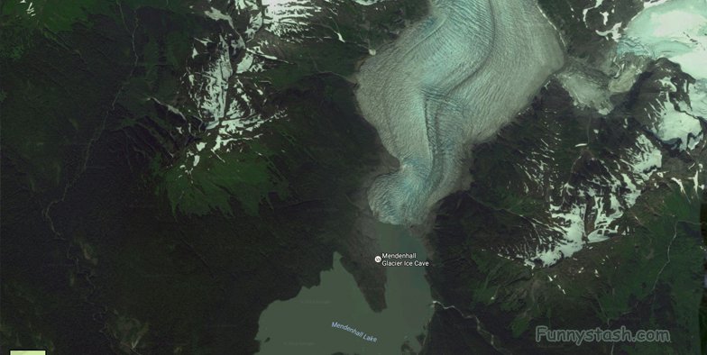
Mendenhall Glacier, Juneau, AK, Juneau, AK, USA
Mendenhall Glacier is a glacier about 13.6 miles long located in Mendenhall Valley with the water running down the glacier creates unique caves within the running glacier making stream runoffs and a uniquely interesting expedition through the glacier caves just be careful as the glacier is always changing in shape as every year is different from the last as it's the melting of the glacier that creates the unique interesting caves that attracts tourists from all over to walk through them and some understandably frightened to go under that can just spectate comfortably from a distance

GPS / 58.4376708,-134.5550109
THE LAKE
The Lake below that the river falls into off the Mendenhall Glacier has it's own ecosystem wife life dependant of it a variety of fish including several type of salmon, Dolly Varden char, and cutthroat trout.
These glaciers are a source of fresh drinking water. Once these glaciers are gone the people relying on this fresh water will be out of their familiar fresh water source. For example Anchorage is one of the most populated cities in Alaska and many people in this city rely on the Eklutna glacier for their freshwater. If the recession of this glacier continues they will be out of their main source of water.

Gps Coordinates / 58.4443326,-134.5510988
Mendenhall Glacier is a glacier about 13.6 miles (21.9 km) long located in Mendenhall Valley, about 12 miles (19 km) from downtown Juneau in the southeast area of the U.S. state of Alaska. The glacier and surrounding landscape is protected as part of the 5,815 acres Mendenhall Glacier Recreation Area, a federally designated unit of the Tongass National Forest.

Gps Coordinates / 58.445857,-134.5511146
Given that average yearly temperatures are currently increasing, and the outlook is for this trend to continue, it is actually possible that the glacier might experience a period of stabilization or slight advance during its retreating march. This is because increasing amounts of warm, moist air will be carried up to the head of the icefield, where colder ambient temperatures will cause it to precipitate as snow. The increased amount of snow will feed the icefield, possibly enough to offset the continually increasing melting experienced at the glacier's terminus. However, this interesting phenomenon will fade away if temperatures continue to climb, since the head of the glacier will no longer have cold enough ambient temperatures to cause snow to precipitate.

Gps Coordinates / 58.4486491,-134.5535599
It was originally known as Sitaantaago ("the Glacier Behind the Town") or Aak'wtaaksit ("the Glacier Behind the Little Lake"), also Latinized as Aakwtaaksit.
Aerial Views of the Glacier Caves Mendenhall Alaska
Aerial View Of Glacier Caves Mendenhall Alaska


