Gps Coordinates / -16.269242,-67.7845837
Deadly Death Road Yungas Road Bolivia Travel VR Adventure 360 Links
P6J8+853 Kilométro 20, Bolivia
Yungas Death Road, Bolivia's most haunted Road, deadliest roads in the world are situated here
It’s estimated that 200 to 300 people traveling on it die each year before repair but it still looks haunted and i’m sure it is haunted. This road has tales that’ll never be heard that would send chills down your spine
Technically within The Amazon Jungle
Gps Coordinates / -16.2699082,-67.7850518
Death Road, a lethal journey in the Bolivian Yungas region. La Carretera de los Yungas was, probably, the most famous road in the world as well as the most dangerous. This gravel dirt track covers a 69-kilometre (43 mi) stretch between La Paz and Coroico, in the Yungas region of Bolivia.
This Location is within the Amazon Rain Forest
Link Location Gps / Gps Link -67.7963206 / Gps Link -67.7986121 / Gps Link -67.800893
Gps Coordinates / -16.280422,-67.7963206 / -16.2836618,-67.7986121 / -16.2860728,-67.800893
The Yungas Road is a cycle route about 60 km long which links the city of La Paz and the Yungas region of Bolivia. It draws about 25,000 tourists per year and is a major La Paz tourist attraction.
Link Location Gps / Gps Link -67.7859365 / Gps Link -67.7866244 / Gps Link -67.7877007
Gps Coordinates / -16.2665943,-67.7859365 / -16.2667226,-67.7866244 / -16.2663051,-67.7877007
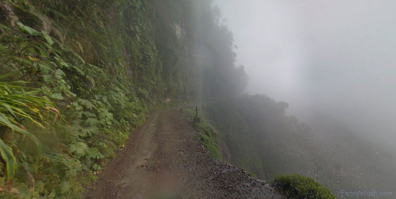
North Yungas road is known as "Death Road" for all of the reasons you'd guess. Driving up or down this 43-mile road is extremely perilous due to fog, landslides, cascades, and cliffs that drop 2,000 feet (610 meters) at every turn.
Link Location Gps / Gps Link -67.7885004 / Gps Link -67.788464 / Gps Link -67.7901434
Gps Coordinates / -16.2659109,-67.7885004 / -16.2653967,-67.788464 / -16.2646081,-67.7901434
Many tour operators cater to downhill mountain biking, providing information, guides, transport and equipment. At least 18 cyclists have died on the road since 1998. The tourist route is a 64-km-long road with 3500 metres of descent.
Link Location Gps / Gps Link -67.7903475 / Gps Link -67.791054 / Gps Link -67.7900519
Gps Coordinates / -16.2645592,-67.7903475 / -16.263719,-67.791054 / -16.261671,-67.7900519
The route includes the Cotapata-Santa Bárbara section. It replaced the old road, built in 1930. It was considered dangerous because of its steep slopes, narrow single track, lack of guardrails, rain, and fog, and was nicknamed the "Road of Death".
Link Location Gps / Gps Link -67.7897557 / Gps Link -67.7891599 / Gps Link -67.7889791
Gps Coordinates / -16.2616761,-67.7897557 / -16.2616328,-67.7891599 / -16.261569,-67.7889791
However, it was not the most dangerous road in the region. Unlike the rest of the country, traffic was left-hand, to allow the driver to assess the distance of their outer wheel from the edge of the road.
Most accidents usually occur with oncoming traffic at snails pace
Link Location Gps / Gps Link -67.7890696 / Gps Link -67.7889791 / Gps Link -67.7864202
Gps Coordinates / -16.2615946,-67.7890696 / -16.261569,-67.7889791 / -16.2608767,-67.7864202
A new alternative route, now part of Route 3, was built during a 20-year period ending in 2006. The modernization included enlarging the carriageway from one to two lanes, asphalt paving, bridges, drainage, guardrails, and the building of a new section between Chusquipata and Yolosa, bypassing the most dangerous sections of the original road.
The Roads are alot safer if you travel by bicycle however The Amazon knows more than a few ways to punch your ticket
Link Location Gps / Gps Link -67.7855199 / Gps Link -67.7850742 / Gps Link -67.7854722
Gps Coordinates / -16.26079,-67.7855199 / -16.2607856,-67.7850742 / -16.2507637,-67.7854722
How many people have died on Yungas Road Bolivia? This road was legendary for its extreme danger. Based on the ratio of death per mile, on an average, 26 vehicles plummet over the edge each year, claiming more than 100 lives. The estimation is that 200 to 300 travellers were killed yearly along the road.
Link Location Gps / Gps Link -67.7853333 / Gps Link -67.7865923 / Gps Link -67.7875533
Gps Coordinates / -16.2508291,-67.7853333 / -16.2439096,-67.7865923 / -16.2438068,-67.7875533
Death Road, a lethal journey in the Bolivian Yungas region. La Carretera de los Yungas was, probably, the most famous road in the world as well as the most dangerous. This gravel dirt track covers a 69-kilometre (43 mi) stretch between La Paz and Coroico, in the Yungas region of Bolivia.
Beautiful Panorama vistas make this a nice place to live but not to travel
Link Location Gps / Gps Link -67.7884742 / Gps Link -67.7515328 / Gps Link -67.7522423
Gps Coordinates / -16.2439299,-67.7884742 / -16.2138311,-67.7515328 / -16.2121546,-67.7522423
The thin road climbs jungle-clad mountains to a height of 4,650m, winding and turning all the while with nauseatingly deep canyons below
Clean up splatter crews are a usual occurrence so they have some stop off areas like here to relax
Link Location Gps / Gps Link -67.7547636 / Gps Link -67.7551542 / Gps Link -67.767727
Gps Coordinates / -16.2094154,-67.7547636 / -16.2096214,-67.7551542 / -16.2161018,-67.767727 /
The road was especially dangerous because is only 3 metres wide and was navigated by trucks and buses, because its constant sheer drops of at least 600m without any barriers or guard rails, the extreme dust clouds from vehicles in the summer and fog all year round often reduced visibility to almost zero and the fog and the rain in the winter months that often washes away parts of the road, reduces visibility as well as causing mudslides and the loosening of rocks from the hillsides above.
Chunks missing at the side possibly due to water erosion
Link Location Gps / Gps Link -67.760211 / Gps Link -67.7846161 / Gps Link -67.784669
Gps Coordinates / -16.2142914,-67.760211 / -16.2691408,-67.7846161 / -16.2690614,-67.784669
It has been estimated that around 200-300 people die each year on the Yungas Road which is only 3 metres wide.
Water eroding the pathway, a pebble at a time makes nine
Link Location Gps / Gps Link -67.7846988 / Gps Link -67.7847652 / Gps Link -67.7848512
Gps Coordinates / -16.2690215,-67.7846988 / -16.2689498,-67.7847652 / -16.2689032,-67.7848512
Shrines to the road gods are throughout these roads, locals are very superstitious
Gps Coordinates / -16.2698421,-67.7850206
To make matters even worse, one is likely to meet groups of cyclists along this road. Internet fame turned this road into a destination for extreme sports enthusiasts, especially downhill bikers. Several tour operators organize such trips. Prices range roughly between $50-$100. At least 13 riders have died in various accidents in the last 10 years.
Signs and shrines welcoming you to Death Road
Gps Link Coordinates / -16.2458686,-67.7859509
The road has gained certain attention in popular culture, including Top Gear’s Bolivia Special and the BBC show World’s Most Dangerous Roads.
This connects the Amazon rainforest region of northern Bolivia, or Yungas, to its capital city, and includes macabre crosses marking many of the spots where vehicles have fallen. Some of the most important accidents happened on 24 July 1983, when a bus veered off the Yungas Road and into a canyon, killing more than 100 passengers in what is said to be Bolivia's worst road accident and in December 1999, after 8 Israeli travelers were killed in a jeep accident on that road. The road was built in the 1930s during the Chaco War by Paraguayan prisoners, and it was modernized during 20 years, ending in 2006. At the end of 2006, after 20 years of construction, a new road (a by-pass) from La Paz to Coroico was opened to the public.
