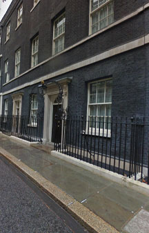
Gps Coordinates / 51.5033029,-0.1276021
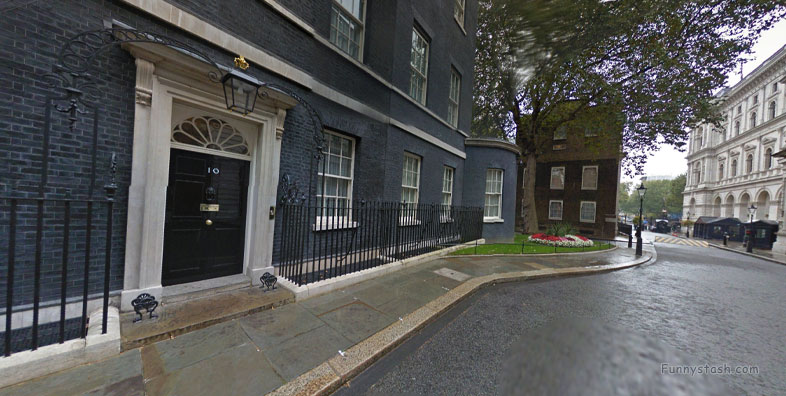
10 Downing Street 2014 Streetview London VR Politics
10 Downing St, London SW1A 2AB
The earliest building known to have stood on the site of Downing Street was the Axe brewery owned by the Abbey of Abingdon in the Middle Ages. By the early 1500s, it had fallen into disuse.
The Romans first came to Britain under the command of Julius Caesar in 55 BC.
Gps Coordinates / 51.5030555,-0.126187
Making their capital at Londinium downriver, the Romans chose Thorney Island - a marshy piece of land lying between two branches of the river Tyburn that flowed from Hampstead Heath to the Thames - as the site for their early settlement.
Link Location Gps / Gps Link -0.1261921 / Gps Link -0.1260267 / Gps Link -0.1275889
Gps Coordinates / 51.503048,-0.1261921 / 51.5031447,-0.1260267 / 51.503259,-0.1275889
These Roman settlements, and those of the Anglo-Saxons and Normans who supplanted them, were not very successful.
George Downing gave his name to the most famous street in the world.
Link Location Gps / Gps Link -0.1275887 / Gps Link -0.127648 / Gps Link -0.1276938
Gps Coordinates / 51.5032738,-0.1275887 / 51.5033049,-0.127648 / 51.5033082,-0.1276938
The area was prone to plague and its inhabitants were very poor.
Link Location Gps / Gps Link -0.1277424 / Gps Link -0.1277917 / Gps Link -0.1278402
Gps Coordinates / 51.5033106,-0.1277424 / 51.5033116,-0.1277917 / 51.5033124,-0.1278402
A charter granted by the Mercian King Offa in the year 785 refers to “the terrible place called Thorney Island”.
Link Location Gps / Gps Link -0.1278476 / Gps Link -0.1278133 / Gps Link -0.1277734
Gps Coordinates / 51.5032858,-0.1278476 / 51.5032863,-0.1278133 / 51.5032851,-0.1277734
It took royal patronage to give the area prestige. King Canute (reigned 1017 to 1035) built a palace in the area, and Edward the Confessor (reigned 1042 to 1066) and William the Conqueror (reigned 1066 to 1087) maintained a royal presence there.
Link Location Gps / Gps Link -0.1277305 / Gps Link -0.1276864 / Gps Link -0.127642
Gps Coordinates / 51.5032836,-0.1277305 / 51.5032828,-0.1276864 / 51.5032823,-0.127642
The position of Westminster (as the area became known) as the centre of government and the church was solidified following the construction of the great abbey nearby, on Edward's orders.
Link Location Gps / Gps Link -0.1275862 / Gps Link -0.1274824 / Gps Link -0.1274359
Gps Coordinates / 51.5032762,-0.1275862 / 51.5032313,-0.1274824 / 51.5032297,-0.1274359
Whitehall Palace was created when Henry VIII confiscated York House from Cardinal Wolsey in 1530 and extended the complex. Today's Downing Street is located on the edge of the Palace site.
Link Location Gps / Gps Link -0.1273885 / Gps Link -0.1273411 / Gps Link -0.1272935
Gps Coordinates / 51.5032269,-0.1273885 / 51.5032237,-0.1273411 / 51.5032204,-0.1272935
The huge residence included tennis courts, a tiltyard for jousting, a bowling green, and a cockpit for bird fights.
Link Location Gps / Gps Link -0.1272464 / Gps Link -0.1272071 / Gps Link -0.1271982
Gps Coordinates / 51.5032166,-0.1272464 / 51.5032171,-0.1272071 / 51.5032272,-0.1271982
Stretching from St James's Park to the Thames, it was the official residence of Tudor and Stuart monarchs until it was destroyed by fire in 1698.
Link Location Gps / Gps Link -0.1271935 / Gps Link -0.1272324 / Gps Link -0.1272772
Gps Coordinates / 51.5032455,-0.1271935 / 51.5032539,-0.1272324 / 51.5032593,-0.1272772
It made the surrounding real estate some of the most important and valuable in London – and the natural home of power.
Link Location Gps / Gps Link -0.1273224 / Gps Link -0.1273674 / Gps Link -0.1274137
Gps Coordinates / 51.5032661,-0.1273224 / 51.503276,-0.1273674 / 51.5032847,-0.1274137
The first domestic house known to have been built on the site of Number 10 was a large building leased to Sir Thomas Knyvet in 1581 by Queen Elizabeth I (reigned 1558 to 1603).
Link Location Gps / Gps Link -0.1274602 / Gps Link -0.1275078
Gps Coordinates / 51.5032925,-0.1274602 / 51.5032992,-0.1275078
He was one of the Queen's favourites and was an MP for Thetford as well as a justice of the peace for Westminster. His claim to fame was the arrest of Guy Fawkes for his role in the gunpowder plot of 1605.
Henry VIII (reigned 1509 to 1547) developed Westminster's importance further by building an extravagant royal residence there.
Gps Coordinates / 51.5032912,-0.1261973
He was knighted in 1604 by Elizabeth's successor, King James I (reigned 1603 to 1625), and the house was extended.
The execution of Charles I in 1649 took place on a scaffold in front of Banqueting House in Whitehall, within earshot of the house.
