Gps Coordinates / 3.2372608,101.6836014
Batu Bat Caves Malaysia's Hindu Tourism VR Map Links
Gombak, 68100 Batu Caves, Selangor, Malaysia
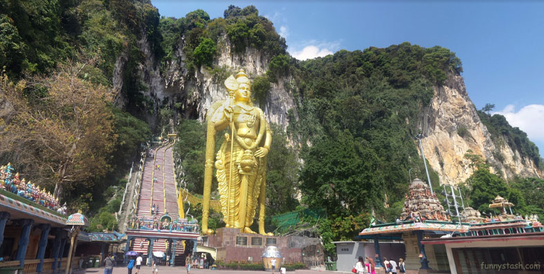
Batu Caves பத்து மலை is a limestone hill that has a series of caves and cave temples in Gombak, Selangor, Malaysia. It takes its name from the Malay word batu, meaning 'rock'. The hill was originally known as Kapal Tanggang from the legend of Si Tanggang. The town nearby is named after the Batu Caves limestone formation. The cave is one of the most popular Hindu shrines outside India, and is dedicated to Lord Murugan. It is the focal point of the Tamil festival of Thaipusam in Malaysia.
Gps Link 3.236516 / Gps Link 3.236516 / Gps Link 3.236516
Gps Coordinates / 3.236516,101.6816512 / 3.236516,101.6816512 / 3.236516,101.6816512
The limestone forming Batu Caves is said to be around 400 million years old. Some of the cave entrances were used as shelters by the indigenous Temuan people, a tribe of Orang Asli. As early as 1860, Chinese settlers began excavating guano for fertilising their vegetable patches. However, they became famous only after the limestone hills were recorded by colonial authorities including Daly and Syers as well as American Naturalist, William Hornaday in 1878.
Street view car Passing Batu Caves
Gps coordinates / 3.2368853,101.6834372
Rock Climbing. Batu Caves is also the centre of rock climbing development in Malaysia for the past 10 years. Batu Caves offers more than 160 climbing routes. The routes are scattered all around the side of Batu Caves, which is made up of limestone hills rising to 150 m. These climbing routes are easily accessed, as most crags start from ground level. These climbing routes often start from the North Eastern side of the cave complex whereas the staircase and temple entrance faces South. This Northeastern area is known as the Damai caves. Abseiling and spelunking trips can be organised with some local adventure companies.
Google Tour Hindu Batu Caves
Gps Link 3.2370096 / Gps Link 3.23737 / Gps Link 3.2383845
Gps Coordinates / 3.2370096,101.6835701 / 3.23737,101.6839308 / 3.2383845,101.6837463
The Batu Caves serve as the focus of the Tamil community's yearly Thaipusam Tamil: தைபூசம் festival. They have become a pilgrimage site not only for Malaysian Hindus, but Hindus worldwide.
Entrance stairs Bat Caves address
Gps coordinates / 3.2373047,101.6837485
A procession begins in the wee hours of the morning on Thaipusam from the Sri Mahamariamman Temple, Kuala Lumpur leading up to Batu Caves as a religious undertaking to Lord Muruga lasting eight hours. Devotees carry containers containing milk as offering to Lord Murugan either by hand or in huge decorated carriers on their shoulders called 'Kavadi'. The kavadi may be simple wooden arched semi-circular supports holding a carrier foisted with brass or clay pots of milk or huge, heavy ones which may rise up to two metres, built of bowed metal frames which hold long skewers, the sharpened end of which pierce the skin of the bearers torso. The kavadi is decorated with flowers and peacock feathers imported from India. Some kavadi may weigh as much as a hundred kilograms.
After bathing in the nearby Sungai Batu (Rocky River), the devotees make their way to the Temple Cave and climb the flights of stairs to the temple in the cave. Devotees use the wider centre staircase while worshippers and onlookers throng up and down those balustrades on either side. When the kavadi bearer arrives at the foot of the 272-step stairway leading up to the Temple Cave, the devotee has to make the arduous climb. Priests attend to the kavadi bearers. Consecrated ash is sprinkled over the hooks and skewers piercing the devotees' flesh before they are removed. No blood is shed during the piercing and removal.
