Gps Coordinates / 4.8067002,36.0355568
Dassanench Village Omorate Ethiopia VR Tourism Places
R24P+M6M Omorate, Ethiopia
Meet some inhabitants of the Dassanech village we are going to visit, among them there is also the boy who will guide us around his village. The huts have a dome shape, the load-bearing structure is made of crossed woods and, at one time, was covered with skins, but now most of them are covered with metal sheet; this is because the cattle has reduced a lot in number and consequently the skins of the animals are scarce, but the sheet under this scorching sun make the huts uninhabitable, therefore, during the day, the women stand under a roof, a sort of collective hut,made of branches and covered with straw or leaves.
Gps Coordinates / 4.8069248,36.0356789
The Dassenech are a nomadic tribe that live in the region where Ethiopia borders Kenya and Sudan. The Daasanach (also known as the Marille or Geleba) are a Cushitic ethnic group inhabiting parts of Ethiopia, Kenya, and South Sudan. Their main homeland is in the Debub Omo Zone of the Southern Nations, Nationalities, and People's Region, adjacent to Lake Turkana. According to the 2007 national census, they number 48,067 people (or 0.07% of the total population of Ethiopia), of whom 1,481 are urban dwellers. Dassench Tent Camps
Link Location Gps / Gps Link 4.8067002 / Gps Link 4.8068361 / Gps Link 4.8069081
Gps Coordinates / 4.8069167,36.0358086 / 4.8068361,36.0354652 / 4.8069081,36.0357666
The Daasanach are also called Marille especially by their neighbours, the Turkana of Kenya. The Daasanach are traditionally pastoralists, but in recent years have become primarily agropastoral. Having lost the majority of their lands over the past fifty years or so, primarily as a result from being excluded from their traditional Kenyan lands, including on both sides of Lake Turkana, and the 'Ilemi Triangle' of Sudan, they have suffered a massive decrease in the numbers of cattle, goats and sheep. As a result, large numbers of them have moved to areas closer to the Omo River, where they attempt to grow enough crops to survive.
Omo River
Gps Coordinates / 4.8100667,36.0479965
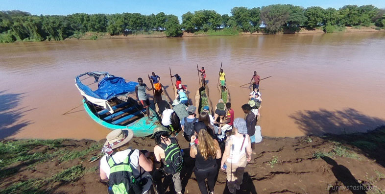
There is a school on the river side of the village. When adults were children the school wasn't there. They had to swim across the river every day" and then they add "I didn't have the money to take the punt, so I used to swim and pay the punt so he could bring me the books and clothes". The the Omo River has a fairly good current and is infested with Nile crocodiles
Link Location Gps / Gps Link 4.8102169 / Gps Link 4.8102169 / Gps Link 4.8102169
Gps Coordinates / 4.810225,36.0486221 / 4.8102169,36.0483398 / 4.8102169,36.0483398
There is much disease along the river (including tsetse, which has increased with forest and woodland development there), however, making this solution to their economic plight difficult. Like many pastoral peoples throughout this region of Africa, the Daasanach are a highly egalitarian society, with a social system involving age sets and clan lineages - both of which involve strong reciprocity relations.
The Daasanach today speak the Daasanach language. It belongs to the Cushitic branch of the Afro-Asiatic family. The language is notable for its large number of noun classes, irregular verb system, and implosive consonants. For instance, the initial D in Daasanach is implosive, sometimes written as 'D.
Link Location Gps / Gps Link 4.8096914
Gps Coordinates / 4.8096914,36.0491142
This is where about 50% of Ethiopia's ethnic groups live: the Konso with their terraced agriculture and rituals; the Mursi with their clay lip plates and barbarian lifestyle; the Hamer with their bull-jumping ceremony, which young men must experience in order to qualify for adulthood; and the Karo with their body painting and adornment. Here unusual traditions such as dance, music and rituals from birth to marriage and burial are still observed in their genuine and original forms
Link Location Gps / Gps Link 4.809711 / Gps Link 4.8097806 / Gps Link 4.8098054
Gps Coordinates / 4.809711,36.0490608 / 4.8097806,36.0489693 / 4.8098054,36.0489006
Modern genetic analysis of the Daasanach indicates that they are more closely related to Nilo-Saharan and Niger-Congo-speaking populations inhabiting Tanzania than they are to the Cushitic and Semitic Afro-Asiatic-speaking populations of Ethiopia. This suggests that the Daasanach were originally Nilo-Saharan speakers, sharing common origins with the Pokot. In the 19th century, the Nilotic ancestors of these two populations are believed to have begun separate migrations, with one group heading southwards into the African Great Lakes region and the other group settling in southern Ethiopia. There, the early Daasanach Nilotes would have come into contact with a Cushitic-speaking population, and eventually adopted this group's Afro-Asiatic language.
Link Location Gps / Gps Link 4.8097582
Gps Coordinates / 4.8097582,36.0487823
Women are circumcised by removing the clitoris. Women who are not circumcised are called animals or boys and cannot get married or wear clothes. Women wear a pleated cowskin skirt and necklaces and bracelets, they are usually married off at 17 while men are at 20. Boys are circumcised. Men wear only a checkered cloth around their waist.
Link Location Gps / Gps Link -10.4626818 / Gps Link 4.8098388 / Gps Link -10.4628324 / Gps Link 4.8098917
Gps Coordinates / 4.809814,36.0488205 / 4.8098388,36.0487823 / 4.8098612,36.048748 / 4.8098917,36.0487976
The Daasanach are a primarily agropastoral people; they grow sorghum, maize, pumpkins and beans when the Omo river and its delta floods. Otherwise the Daasanach rely on their goats and cattle which give them milk, and are slaughtered in the dry season for meat and hides. Sorghum is cooked with water into a porridge eaten with a stew. Corn is usually roasted, and sorghum is fermented into beer. The Daasanach who herd cattle live in dome-shaped houses made from a frame of branches, covered with hides and woven boxes (which are used to carry possessions on donkeys when the Daasanach migrate). The huts have a hearth, with mats covering the floor used for sleeping. The Dies, or lower class, are people who have lost their cattle and their way of living. They live on the shores of Lake Turkana hunting crocodiles and fishing. Although their status is low because of their lack of cattle, the Dies help the herders with crocodile meat and fish in return for meat.

