Gps Coordinates / 18.3406919,-66.823097
3rd Largest Underground Cave River Camuy Adventure VR Panorama Locations
85RG+7QC Rafael Capó, Hatillo, Puerto Rico
Third-largest underground river in the world -- Thousands of bats -- "Discovered" in 1958 -- 10 miles of caverns, 220 caves and 17 entrances
Gps Coordinates / 18.3475342,-66.8282362
The Parque Nacional de las Cavernas del Río Camuy (Camuy River Cave Park) is a cave system in Puerto Rico. It is located between the municipalities of Camuy, Hatillo, and Lares in northwestern Puerto Rico, but the main entrance to the park is located in Quebrada, Camuy.
Link Location Gps / Gps Link -66.8274242 / Gps Link -66.8199732 / Gps Link -66.8218729
Gps Coordinates / 18.3467287,-66.8274242 / 18.3450976,-66.8199732 / 18.3450279,-66.8218729
The caverns are part of a large network of natural limestone caves and underground waterways carved out by the third-largest underground river in the world, the Río Camuy (Camuy River). Since November 2010, night tours called ECO NIGHTS have been organized weekly under special reservations. The tours start with the screening of a short movie in a 90-seat theater, explaining the Rio Camuy Cave System and site safety rules, followed by a train ride that takes visitors into the entrance of Clara Cave.
Link Location Gps / Gps Link -66.8219844 / Gps Link -66.822143 / Gps Link -66.8233673
Gps Coordinates / 18.3462514,-66.8219844 / 18.3462823,-66.822143 / 18.3467916,-66.8233673
The cave system was "discovered" in 1958 and was first documented in the 1973 book Discovery at the Río Camuy by Russell and Jeanne Gurnee, but there is archaeological evidence that these caves were explored hundreds of years ago by the Taíno Indians, Puerto Rico's first inhabitants.
Link Location Gps / Gps Link -66.822786 / Gps Link -66.8230163 / Gps Link -66.8231363
Gps Coordinates / 18.3408247,-66.822786 / 18.3407467,-66.8230163 / 18.3406401,-66.8231363
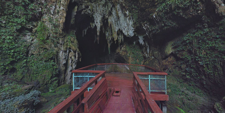
Over 10 miles of caverns, 220 caves and 17 entrances to the Camuy cave system have been mapped so far. Clara Cave is the main attraction at the Rio Camuy Cave Park. A single chamber of this cave system has been developed for the public, starting in 1986. Regular cavern guided tours and audio tours are available at the site.
Link Location Gps / Gps Link -66.819445 / Gps Link -66.8231888 / Gps Link -66.8236759
Gps Coordinates / 18.3447217,-66.819445 / 18.3447699,-66.8231888 / 18.3466626,-66.8236759
This, however, is only a fraction of the entire system which many experts believe still holds another 800 caves. Once walking down the 205 steps into the sinkhole, the cave itself is off limits to reach. Only experienced spelunkers can penetrate the cave and the underground river with special permission from the National Parks Company of Puerto Rico.
Link Location Gps / Gps Link -66.8235298 / Gps Link -66.8238545 / Gps Link -66.8238603
Gps Coordinates / 18.3465675,-66.8235298 / 18.3463203,-66.8238545 / 18.3463146,-66.8238603
Only a small part of the complex is open to the public. The huge chamber is 700 ft in length and 215 ft high. Once inside this chamber, visitors are able to see an entrance from the roof of "Sumidero de Empalme" that is 60m from the surface, as well as stalactites, stalagmites, unique formations and thousands of bats.
Gps Coordinates / 18.3462978,-66.8235969
The Camuy River Cave Park is home to more than 13 species of bats, and hundreds of other insect, arachnid and frog species. The Río Camuy is the world's third-largest subterranean river. The park closes once it reaches its 1,500 visitors daily capacity. 16 entrances, over 220 caves, two other smaller cave systems and more than 10 miles have been mapped so far and experts still say the cave system could be much larger.
Link Location Gps / Gps Link -66.8238594 / Gps Link -66.8238268 / Gps Link -66.8238334
Gps Coordinates / 18.3463087,-66.8238594 / 18.3462764,-66.8238268 / 18.3462483,-66.8238334
The 268-acre park built around the cave system features tours of some of the caves and sinkholes, and is one of the most popular natural attractions in Puerto Rico. Giant sinkhole measuring 650 ft wide. The Camuy River can be seen 400 ft below from three observation platforms that are located at different points alongside the opening of the impressive crater. The sinkhole is located where the borders of the towns of Camuy, Hatillo and Lares meet. Each town has its own platform overlooking the sinkhole.
Link Location Gps / Gps Link -66.8238734 / Gps Link -66.8238309 / Gps Link -66.8238472
Gps Coordinates / 18.3461697,-66.8238734 / 18.3463008,-66.8238309 / 18.3461604,-66.8238472
After restorations necessitated by Hurricane Maria, a destructive storm that struck Puerto Rico in 2017, the park re-opened on March 24, 2021.
The park has been closed since Hurricane Maria struck Puerto Rico in September 2017. The park was scheduled to reopen in December of 2021.
