


Gps Coordinates / -8.8832872,147.7377843
Kokoda Trail Papua New Guinea VR Adventure
4P8Q+M4M Kokoda Track, Papua New Guinea
The Kokoda Challenge Race is an endurance running race that was revived on 27 August 2005. The race originally ran in 1975 but stopped before becoming an annual event. The track was the location of the 1942 World War II battle between Japanese and Allied, primarily Australian forces in what was then the Australian territory of Papua.
WW2 Relics of this trail can still be found, rainforest landslides make marked possible locations very difficult to pindown

Gps Coordinates / -9.033425,147.739444
DEATHS
Since 2001, there has been a rapid increase in the number of people walking the track. Six Australian trekkers have died from hyponatremia while attempting to walk the track. Four of those deaths occurred in 2009, with two in the same week in April and another two 8 days apart in September and October. The deaths have sparked calls for mandatory fitness tests for all walkers before starting.
Just getting to the start track trail from the highway can be quite the adventure through tamed urban areas


Link Location Gps / Gps Link -9.412958 / Gps Link -9.414311 / Gps Link -9.362014
Gps Coordinates / -9.412958,147.441522 / -9.414311,147.441003 / -9.362014,147.487925
The World War II battle sites were a key reason for cultural listing along with the unique cultures of the Koiari peoples. The Owen Stanley Ranges, through which the Kokoda Track passes, is one of the most biologically important areas in the Asia Pacific with over 4000 plant species and many endemic bird and animal species.
The Kokoda Track or Trail is a single-file foot thoroughfare that runs 60 miles overland and 37 miles in a straight line through the Owen Stanley Range in Papua New Guinea.


Link Location Gps / Gps Link -9.362053 / Gps Link -9.360033 / Gps Link -9.360192
Gps Coordinates / -9.362053,147.488194 / -9.360033,147.497269 / -9.360192,147.497689
There are a number of guesthouses located along the way, some at villages and others at traditional rest spots. The main villages passed through (from Owers' Corner) are Naoro, Menari, Efogi Creek 1 & 2, Kagi or Naduri (if shortcut is taken), Alolo, Isurava, Hoi, Kovolo. Villagers are increasingly taking part in the commercial opportunities created by the growing number of tourists. In October 2006, some were known to be selling cans of soft drink and beer at double the price payable in Port Moresby.
The track can be walked from either direction. It can take up to 12 days to complete, depending on fitness and rest time involved. Locals are renowned for being able to regularly complete it in 3 days.


Link Location Gps / Gps Link -9.340861 / Gps Link -9.320875 / Gps Link -9.316122
Gps Coordinates / -9.340861,147.524483 / -9.320875,147.530003 / -9.316122,147.539517
The Kokoda Track Authority (the PNG Special Purpose Authority with responsibility for managing the Track) requires tour operators to hold a Commercial Operators Licence to lead treks along the Kokoda Track and purchase a trek permit. Licensed operators carry first aid kits, undertake first aid training, carry radios or satellite phones, respect the people who live along the Track and ensure their porters and guides are treated in a professional manner.
The track can be walked from either direction. It can take up to 12 days to complete


Link Location Gps / Gps Link -9.312272 / Gps Link -9.297058 / Gps Link -9.265322
Gps Coordinates / -9.312272,147.553547 / -9.297058,147.563431 / -9.265322,147.611497
CONTINUED DEATHS
In August 2009, a group of trekkers were killed when their light plane, Airlines PNG Flight 4684, crashed en route to Kokoda Station. All 13 people on board, including 9 Australian trekkers, were killed in the crash. As a result, the Australian Government committed $1.8 million to improve the safety of airstrips at Kokoda, Menari, Kagi, Melei, Efogi, and Naduri, villages located along the track. A second radio channel was also installed to deal with emergencies and maintenance work.
The deaths have sparked calls for mandatory fitness tests for all walkers before starting.


Link Location Gps / Gps Link -9.244503 / Gps Link -10.4302518 / Gps Link -9.194872
Gps Coordinates / -9.244503,147.614817 / -9.163981,147.645275 / -9.194872,147.623147
There has been much debate in Australia about whether it should be called the "Kokoda Trail" or the "Kokoda Track". The monument at Owers' Corner uses both terms: "Track" on one side and "Trail" on the other. The earliest mention of the route in an Australian newspaper may be in The Argus on Wednesday 29 July 1942 in a map when it refers to "the Buna Kokoda-Moresby track". "Kokoda Trail" was gazetted as the official name of the route by the Australian administration of Papua New Guinea in 1972.
In October 2009, Don Vale became the oldest Australian (at 83) to successfully complete the Kokoda Track.


Link Location Gps / Gps Link -9.130942 / Gps Link -9.072269 / Gps Link -9.149414
Gps Coordinates / -9.130942,147.675442 / -9.072269,147.734297 / -9.149414,147.730803
The diary of the Australian Army's 2/33rd Battalion records the route being officially designated as the "Kokoda Trail" in September 1942. The Australian Army has used "Kokoda Trail" as a battle honour since 1957. The Australian War Memorial (AWM) says that "trail" is probably of United States origin but has been used in many Australian history books and "appears to be used more widely".


Link Location Gps / Gps Link -9.100211 / Gps Link -9.005442 / Gps Link -8.992900
Gps Coordinates / -9.100211,147.736839 / -9.005442,147.738097 / -8.992900,147.735325
In November 2009, Australian paralympian Kurt Fearnley (born without the lower section of his spine) completed the track, crawling north to south, in 11 days. A multiple paralympic gold medalist (T54 Marathon in Athens and Beijing), he used customized shin pads and wrist guards. His journey was to raise awareness of men's health issues and was inspired by the story of Corporal John Metson, who crawled the track for three weeks, refusing the assistance of a stretcher on the grounds it would burden his comrades.


Link Location Gps / Gps Link -8.992364 / Gps Link -8.986553 / Gps Link -8.984197
Gps Coordinates / -8.992364,147.735233 / -8.986553,147.735144 / -8.984197,147.732283
Between July 1942 and November 1942, a series of battles, afterwards called the Kokoda Track Campaign, were fought between the Japanese and Australian forces. This action was memorialised in the newsreel documentary Kokoda Front Line!, filmed by cameraman Damien Parer, which won Australia's first Academy Award for its director Ken G. Hall in 1942.


Link Location Gps / Gps Link -8.927242 / Gps Link -8.877969
Gps Coordinates / -8.927242,147.742492 / -8.877969,147.737200
After the war, the track fell into disuse and disappeared in many places. John Landy, the long-distance runner, set a record of four days for the crossing using carriers and guides during the 1950s, and in 1964 Angus Henry, the art teacher at Sogeri High School, along with two of his students, John Kadiba and Misty Baloiloi, set a new record which was to stand until after the millennium by completing the journey in three and a quarter days without guides, carriers or any signposts or bridges.

Gps Coordinates / -9.3620703,147.4881267
Despite the historical use of "Trail", "Track" gained dominance in the 1990s, with the Australian Macquarie Dictionary stating that while both versions were in use, Kokoda Track "appears to be the more popular of the two".
-
Aerial View Of The Kokoda Trail begins at Sogeri Highway
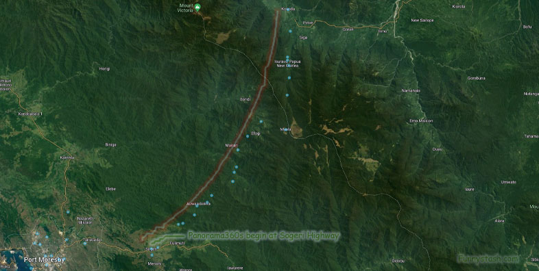
Aerial View Location of Kokoda Trail Track
According to historian Stuart Hawthorne, before World War II, the route was referred to as "the overland mail route" or "the Buna road". He states that "Kokoda Trail" became common because of its use in Australian newspapers during the war, the first known instance being in Sydney's Daily Mirror on 27 October 1942. However, all three terms Kokoda Track, Kokoda Trail and Buna-Kokoda road were commonly used during World War II in Australian newspapers from September 1942.


