Gps Coordinates / 13.2074821,103.9737442
Floating Village VR 2014 Kampong Phluk Cambodia
6X4F+XFX Kampong Phluk, Cambodia
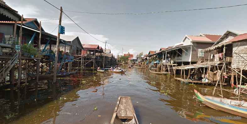
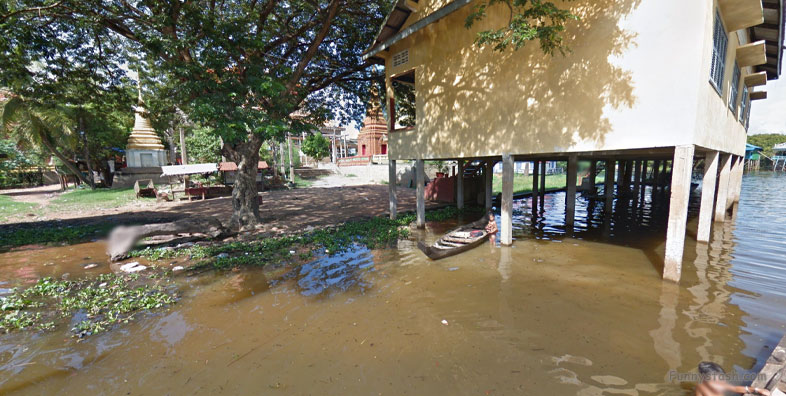
Many houses and buildings are constructed on stilts ranging from 6 m to 9 m to accommodate the changes in water level between wet and dry seasons.
Gps Coordinates / 13.2089098,103.9737269
During the dry season (November-April) as the river thins due to receding water, many turn to farming to supplement their income.
Link Location Gps / Gps Link 13.2088883 / Gps Link 13.2094097 / Gps Link 13.2088929
Gps Coordinates / 13.2088883,103.9736117 / 13.2094097,103.9737963 / 13.2088929,103.9737098
Tourism, which started in the village approximately 10 years ago, is also a growing part of the local economy.
Link Location Gps / Gps Link 13.2088139 / Gps Link 13.2086759 / Gps Link 13.2084948
Gps Coordinates / 13.2088139,103.9737036 / 13.2086759,103.9737046 / 13.2084948,103.9737304
As of 2019, the commune has 911 families with a total population of 3,707.
Link Location Gps / Gps Link 13.2083973 / Gps Link 13.2083464 / Gps Link 13.2082975
Gps Coordinates / 13.2083973,103.9737355 / 13.2083464,103.9737287 / 13.2082975,103.9737377
The commune consist of three villages: Tnaot Kambot (ត្នោតកំបុត), Dey Krahom (ដីក្រហម), and Kok Kdol (គោគក្ដុល).
Link Location Gps / Gps Link 13.2080779 / Gps Link 13.2078969 / Gps Link 13.2078778
Gps Coordinates / 13.2080779,103.9737419 / 13.2078969,103.9737488 / 13.2078778,103.9737493
Located in Siem Reap, Cambodia, Kompong Phluk is a collection of three floating villages totaling somewhere between 2000 - 3000 residents.
Link Location Gps / Gps Link 13.2077814 / Gps Link 13.207699 / Gps Link 13.2076092
Gps Coordinates / 13.2077814,103.9737506 / 13.207699,103.9737494 / 13.2076092,103.9737444
Near the Tonle Sap Lake making it a convenient home for fishermen.
Link Location Gps / Gps Link 13.2073377 / Gps Link 13.2070176 / Gps Link 13.2067951
Gps Coordinates / 13.2073377,103.973754 / 13.2070176,103.9737182 / 13.2067951,103.9736885
Has the largest mangrove forest in the region (called the flooded forest) as it is under water for part of the year.
Link Location Gps / Gps Link 13.2063783 / Gps Link 13.2062085 / Gps Link 13.2060514
Gps Coordinates / 13.2063783,103.9737202 / 13.2062085,103.9737229 / 13.2060514,103.973725
Phluk and the greater Tonle Sap lake is a UNESCO Biosphere reserve, it contains unique plant species, fish, and animals, many of which find themselves endangered.
Link Location Gps / Gps Link 13.2057934 / Gps Link 13.2055346 / Gps Link 13.2055018
Gps Coordinates / 13.2057934,103.9737085 / 13.2055346,103.9737253 / 13.2055018,103.9737754
Before the Khmer Rouge, Kompong Phluk was not an organized village.
Link Location Gps / Gps Link 13.2053977 / Gps Link 13.2054103 / Gps Link 13.2054892
Gps Coordinates / 13.2053977,103.9740504 / 13.2054103,103.9741627 / 13.2054892,103.9743454
This community existed until the Khmer Rouge arrived in Siem Reap in 1975. These soldiers burned down floating village homes and moved families to central work sites.
Link Location Gps / Gps Link 13.2055074 / Gps Link 13.2055521 / Gps Link 13.2057851
Gps Coordinates / 13.2055074,103.9745944 / 13.2055521,103.9750093 / 13.2057851,103.9752253
After the Khmer Rouge, families began returning to the area to resume their lives as fishermen.
Link Location Gps / Gps Link 13.2059071 / Gps Link 13.2051628 / Gps Link 13.2050088
Gps Coordinates / 13.2059071,103.9753136 / 13.2051628,103.9749864 / 13.2050088,103.974943
The floating village was a difficult place to live in the 1980’s due to a lack of essential services and Khmer Rouge remnants, but it started to improve in the 1990’s when aid organizations began working in the village.
Link Location Gps / Gps Link 13.2046217 / Gps Link 13.2045913 / Gps Link 13.2042248
Gps Coordinates / 13.2046217,103.97474 / 13.2045913,103.9748554 / 13.2042248,103.9749073
They improved roads, built schools, taught fishing and conservation and other essential tasks.
Link Location Gps / Gps Link 13.2037227 / Gps Link 13.2032282 / Gps Link 13.203126
Gps Coordinates / 13.2037227,103.9747731 / 13.2032282,103.9748179 / 13.203126,103.9748285
2000’s residents worked to develop an ecotourism site to showcase the village’s unique floating homes, vast mangrove forests, and Tonle Sap lake.
This boat ticket costs USD 20 per person, and the return trip lasts about one hour.
Link Location Gps / Gps Link 13.202788 / Gps Link 13.2026666 / Gps Link 13.2025582
Gps Coordinates / 13.202788,103.9748728 / 13.2026666,103.9749459 / 13.2025582,103.975015
The forest is approximately 6000 hectares and growing due to community conservation efforts which discourage logging.
Link Location Gps / Gps Link 13.2024873 / Gps Link 13.2014173 / Gps Link 13.2060577
Gps Coordinates / 13.2024873,103.9750879 / 13.2014173,103.9750776 / 13.2060577,103.9761175
The village has a rowing boat cooperative that offers tours of the flooded forest during the rainy season.
The second boat is an optional rowboat or canoe that goes through the flooded forest.
Link Location Gps / Gps Link 13.2060264 / Gps Link 13.205665 / Gps Link 13.2182985
Gps Coordinates / 13.2060264,103.9762145 / 13.205665,103.976961 / 13.2182985,103.9746555
There are two boats you can take in the village. The first boat takes tourists from the end of the road to the village itself.
The boat ticket costs USD 5 per person, and the ride lasts about 20 - 30 minutes.
Link Location Gps / Gps Link 13.218512 / Gps Link 13.2186355 / Gps Link 13.2187807 /
Gps Coordinates / 13.218512,103.9746099 / 13.2186355,103.9745865 / 13.2187807,103.9745584 /
After visiting the village, school, and pagoda, it travels onwards to the Tonle Sap lake.


