Gps Coordinates / 63.8932304,-22.2805214
-
March 2021
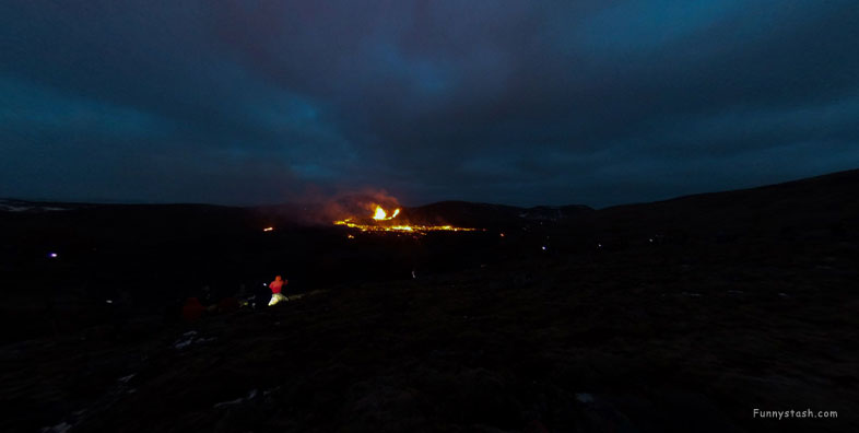
Volcano Geldingadalir 2021-22 VR Iceland
Grindavíkurbær, 241, Iceland
Classified as it's own independent Volcano early September 2021, however it started to awake to residents earlier on March 2021 as seen above.
Link Location Gps / Gps Link -22.2776556 / Gps Link -22.2675533 / Gps Link -22.2744484
Gps Coordinates / 63.8849174,-22.2776556 / 63.8911171,-22.2675533 / 63.8818359,-22.2744484
-
April 2021 / April 2021 / Jun 2021
Eruption fissures in Geldingadalir 19 March 2021, an effusive eruption started at approximately 20:45 local time in Geldingadalir
Fagradalsfjall had been dormant for 6,000 years. An area 3 miles wide and 10 miles long.
Gps Coordinates / 63.8736451,-22.2888485
-
May2021
The singular "Geldingadalur" is also often used) to the south of Fagradalsfjall, the first known eruption on the peninsula in about 800 years.
On 14 August, lava spurted from what appeared to be a hole on the crater wall, and this turned out to be an independent eruption.
Link Location Gps / Gps Link -22.2721212 / Gps Link -22.2553172 / Gps Link -22.2742667
Gps Coordinates / 63.8962343,-22.2721212 / 63.8987109,-22.2553172 / 63.8964088,-22.2742667
-
Aug 2022 / Aug 2022 / Sept 2022
On 13 April 2021, four new craters formed in Geldingadalir within the lava flows. The lava output which had been somewhat reduced over the last days, increased again.
By 2 May 2021, only one fissure, Vent 5 that appeared near the initial eruption site on Geldingadalir, remained active.
Link Location Gps / Gps Link -22.2771225 / Gps Link -22.269727 / Gps Link -22.2651397 / Gps Link -22.2568645
Gps Coordinates / 63.8946075,-22.2771225 / 63.8933351,-22.269727 / 63.896036,-22.2651397 / 63.897583,-22.2568645
-
March 2021 / June 2021 / Sept 2021 / Aug 2022
The rim of the volcano itself had risen to a height of 1,096 feet above sea level by September 2021. The lava flowed into the Meradalir valleys and later the Nátthagi valley.
It developed into a volcano with the occasional explosive eruptions within its crater that sometimes reached heights of hundreds of meters.
Gps Coordinates / 63.8980942,-22.2569942
-
Aug 2022
After eight and a half days of inactivity at the main volcano, lava broke through the surface in the lava field to the north of the crater in a number of places.
.
.
.
Visit Iceland, Iceland has some tourist sites below to inspire personal map visits below, check them out and let us know how you got along
-
.
.
.
