Gps Coordinates / -19.529419,169.449498
Volcano VR Mount Yasur Tanna Island Adventure Locations
Mount Yasur (Active Volcano), Vanuatu
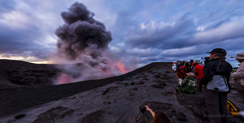
Mount Yasur is a volcano on Tanna Island, Vanuatu, 361 m (1,184 ft) high above sea level, on the coast near Sulphur Bay, northeast of the taller Mount Tukosmera, which was active in the Pleistocene.
The glow of the volcano was apparently what attracted Captain James Cook on the first European journey to the island in 1774.
Gps Coordinates / -19.52962,169.4499493
It has a largely unvegetated pyroclastic cone with a nearly circular summit crater 400m in diameter.
Link Location Gps / Gps Link -19.5314825 / Gps Link -19.5317645 / Gps Link -19.53282
Gps Coordinates / -19.5314825,169.4465971 / -19.5317645,169.449659 / -19.53282,169.450955
It is a stratovolcano, caused by the eastward-moving Indo-Australian Plate being subducted under the westward-moving Pacific Plate.
Today, the mountain is a sacred area for the John Frum cargo cult.
Link Location Gps / Gps Link -19.53585 / Gps Link -19.5232048 / Gps Link -19.5210404
Gps Coordinates / -19.53585,169.4498883 / -19.5232048,169.4400177 / -19.5210404,169.4404593
Its eruptions, which often occur several times an hour, are classified as Strombolian or Vulcanian. A large lava plain creeps across the valley at the base.
800-year long eruption being named the lighthouse of the Pacific.
Gps Coordinates / -19.5129814,169.4326324
-
The importance of the volcano to Tanna's tourism industry has resulted in the local government creating levels to alert people. These levels range from 0-5 and notes that An eruption may occur at any level.
.
Level 0 - Normal
Level 1 - Signs of Volcanic Unrest
Level 2 - Major Unrest
Level 3 - Minor Eruption
Level 4 - Moderate Eruption
Level 5 - Very Large Eruption
