Gps Coordinates / 56.0149116,23.4153055
Hill Of Crosses Kalnas Lithuanian VR Tour
Meškuičių sen., 81439, Lithuania, Europe
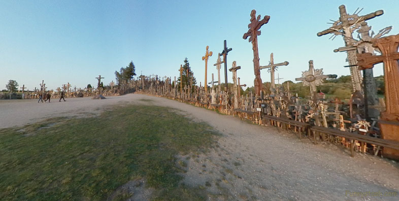
Hill of Crosses is a site of pilgrimage about 12 km north of the city of Šiauliai, in northern Lithuania. The precise origin of the practice of leaving crosses on the hill is uncertain, but it is believed that the first crosses were placed on the former Jurgaičiai or Domantai hill fort after the 1831 Uprising.
Gps Coordinates / 56.0151993,23.4156199
Alot of amazing history on this hill regardless of your beliefs.
here by Catholic pilgrims. The exact number of crosses is unknown, but estimates put it at about 55,000 in 1990 and 100,000 in 2006. It is a major site of Catholic pilgrimage in Lithuania.
Link Location Gps / Gps Link 56.0152245 / Gps Link 56.0152359 / Gps Link 56.0152697
Gps Coordinates / 56.0152245,23.4154034 / 56.0152359,23.4160576 / 56.0152697,23.4161495
Over the generations, the place has come to signify the peaceful endurance of Lithuanian people despite the threats they faced throughout history. After the 3rd partition of the Polish–Lithuanian Commonwealth in 1795, Lithuania became part of the Russian Empire. Poles and Lithuanians unsuccessfully rebelled against Russian authorities in 1831 and 1863. These two uprisings are connected with the beginnings of the hill: as families could not locate bodies of perished rebels, they started putting up symbolic crosses at the site of a former hill fort
Link Location Gps / Gps Link 56.0152222 / Gps Link 56.0152298 / Gps Link 56.0152407
Gps Coordinates / 56.0152222,23.4160737 / 56.0152298,23.4161249 / 56.0152407,23.4161668
When the old political structure of Eastern Europe fell apart in 1918, Lithuania once again declared its independence. Throughout this time, the Hill of Crosses was used as a place for Lithuanians to pray for peace, for their country, and for the loved ones they had lost during the Wars of Independence.
Link Location Gps / Gps Link 56.0153809 / Gps Link 56.0152469 / Gps Link 56.0153999
Gps Coordinates / 56.0153809,23.4169369 / 56.0152469,23.4162053 / 56.0153999,23.416809
The site took on a special significance during the years 1944–1990, when Lithuania was occupied by the Soviet Union. Continuing to travel to the hill and leave their tributes, Lithuanians used it to demonstrate their allegiance to their original identity, religion and heritage. It was a venue of peaceful resistance, although the Soviets worked hard to remove new crosses, and bulldozed the site at least three times (including attempts in 1963 and 1973). There were even rumors that the authorities planned to build a dam on the nearby Kulvė River, a tributary to Mūša, so that the hill would end up underwater.
Link Location Gps / Gps Link 56.0152555 / Gps Link 56.0152606 / Gps Link 56.0153745
Gps Coordinates / 56.0152555,23.416234 / 56.0152606,23.4162479 / 56.0153745,23.4171154
On September 7, 1993, Pope John Paul II visited the Hill of Crosses, declaring it a place for hope, peace, love and sacrifice. In 2000 a Franciscan hermitage was opened nearby. The interior decoration draws links with La Verna, the mountain where St. Francis is said to have received his stigmata. In May 2013, Šiauliai District Municipality adopted rules regarding the placement of crosses. People are allowed to erect wooden crosses less than 9.8 ft in height with no permits.
Link Location Gps / Gps Link 56.0152882 / Gps Link 56.0153738 / Gps Link 56.0150578
Gps Coordinates / 56.0152882,23.4173445 / 56.0153738,23.4173887 / 56.0150578,23.4167183
The Hill of Crosses, where people not only from Lithuania have put crosses for couple centuries, witnesses faithfulness and trust of a Christian community to Christ and his Cross. This is an expression of a spontaneous religiousness of the people, and is a symbol not of grief and death but of Faith, Love and Sacrifice. From here the Pope blessed all people of Lithuania and all of Christian Europe.
Link Location Gps / Gps Link 56.0150971 / Gps Link 56.0149763 / Gps Link 56.0149302
Gps Coordinates / 56.0150971,23.4169264 / 56.0149763,23.4162488 / 56.0149302,23.415866
The Hill of Crosses is situated in the middle of an arable land, sixteen kilometers from Šiauliai. It is seen from Šiauliai – Ryga highway. The hill is 60 meters long and 40-50 meters wide.
Link Location Gps / Gps Link 56.0148128 / Gps Link 56.0147263 / Gps Link 56.0146225 / Gps Link 56.0146931
Gps Coordinates / 56.0148128,23.4153543 / 56.0147263,23.4151405 / 56.0146225,23.4149476 / 56.0146931,23.4147387
In 1994 during his visit to a Franciscan monastery of the mount of Verna (Italy), the Pope John Paul II encouraged the brothers to build a monastery by the Hill of Crosses. A hermit of the Franciscan Brothers was consecrated on July 7, 2000. It is built 300 meters away from the Hill and has sixteen cells. It serves as a novitiate of the Lithuanian Franciscan province of St. Casimir, but the monastery is also open to the pilgrims who look for silence and peace.
Gps Coordinates / 56.0144376,23.4146967
In December 2019, a tourist from China removed and tossed away a cross believed to be set up by the Hong Kong pro-democracy camp. She later condemned the protesters in a Twitter post and in an Instagram video saying, "We have done a good thing today. Our motherland is great." Lithuanian Foreign Minister Linas Linkevičius condemned the woman's action in a tweet that called it a "shameful, disgraceful act of vandalism" and said such behavior "can't and won't be tolerated".
