


Gps Coordinates / 41.8900797,12.4930175
Rome Colosseum Tourism VR Map Links
VFRV+26J Rome, Metropolitan City of Rome, Italy
The Colosseum is built of travertine limestone, tuff (volcanic rock), and brick-faced concrete. The Colosseum could hold an estimated 50,000 to 80,000 spectators at various points in its history having an average audience of some 65,000, it was used for gladiatorial contests and public spectacles including animal hunts, executions, re-enactments of famous battles, and dramas based on Roman mythology, and briefly mock sea battles. The building ceased to be used for entertainment in the early medieval era. It was later reused for such purposes as housing, workshops, quarters for a religious order, a fortress, a quarry, and a Christian shrine.
Roman Colosseum lit up at night time

The Colosseum is an oval amphitheatre in the centre of the city of Rome, Italy, just east of the Roman Forum. It is the largest ancient amphitheatre ever built, and is still the largest standing amphitheatre in the world today, despite its age. Construction began under the emperor Vespasian (r. 69–79 AD) in 72 and was completed in 80 AD under his successor and heir, Titus (r. 79–81). Further modifications were made during the reign of Domitian (r. 81–96).


Link Gps 41.8911988 / Link Gps 41.889873 / Link Gps 41.8903868
Gps Coordinates / 41.8911647,12.4918343 / 41.889873,12.491812 / 41.8903868,12.4925186
Although substantially ruined because of earthquakes and stone-robbers, the Colosseum is still an iconic symbol of Imperial Rome and was listed as one of the New7Wonders of the World. It is one of Rome's most popular tourist attractions and also has links to the Roman Catholic Church, as each Good Friday the Pope leads a torchlit "Way of the Cross" procession that starts in the area around the Colosseum.
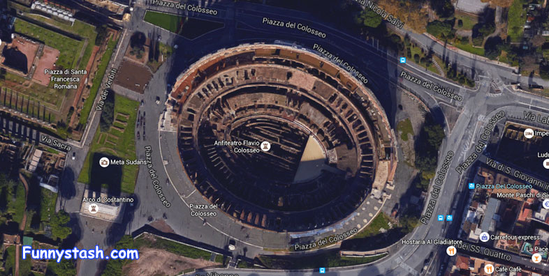
Check Out the Roman Colosseum from the air


Link Location Gps / Gps Link 41.8893726 / Gps Link 41.8899096 / Gps Link 41.8899078
Gps Coordinates / 41.8893726,12.4924378 / 41.8899096,12.4931489 / 41.8899078,12.4930369
During the 16th and 17th century, Church officials sought a productive role for the Colosseum. Pope Sixtus V (1585–1590) planned to turn the building into a wool factory to provide employment for Rome's prostitutes, though this proposal fell through with his premature death. In 1671 Cardinal Altieri authorized its use for bullfights; a public outcry caused the idea to be hastily abandoned.
Same Viewport of different season the middle one in rain recolours the stone while wet


Link Location Gps / Gps Link 41.8899384 / Gps Link 41.8899912 / Gps Link 41.8899956
Gps Coordinates / 41.8899384,12.4929857 / 41.8899912,12.4929464 / 41.8899956,12.4929314
The Colosseum is today one of Rome's most popular tourist attractions, receiving millions of visitors annually. The effects of pollution and general deterioration over time prompted a major restoration programme carried out between 1993 and 2000
Snowfall around the Colosseum


Link Location Gps / Gps Link 41.88998 / Gps Link 41.8896662 / Gps Link 41.8897824
Gps Coordinates / 41.88998,12.4922917 / 41.8896662,12.4932213 / 41.8897824,12.4937904
Construction of the Colosseum began under the rule of Vespasian in around 70–72 AD (73–75 AD according to some sources). The Colosseum had been completed up to the third story by the time of Vespasian's death in 79. The top level was finished by his son, Titus, in 80, and the inaugural games were held in 80 or 81 AD.


Link Location Gps / Gps Link 41.8900384 / Gps Link 41.8907604 / Gps Link 41.8902317
Gps Coordinates / 41.8900384,12.4936113 / 41.8907604,12.492878 / 41.8902317,12.4933567
The Colosseum underwent several radical changes of use. By the late 6th century a small chapel had been built into the structure of the amphitheater, though this apparently did not confer any particular religious significance on the building as a whole. The arena was converted into a cemetery. The numerous vaulted spaces in the arcades under the seating were converted into housing and workshops, and are recorded as still being rented out as late as the 12th century.


Link Location Gps / Gps Link 41.8899845 / Gps Link 41.8903736 / Gps Link 41.8900945
Gps Coordinates / 41.8899845,12.4916988 / 41.8903736,12.4915369 / 41.8900945,12.4916968
Severe damage was inflicted on the Colosseum by the great earthquake in 1349, causing the outer south side, lying on a less stable alluvial terrain, to collapse. Much of the tumbled stone was reused to build palaces, churches, hospitals and other buildings elsewhere in Rome. A religious order moved into the northern third of the Colosseum in the mid-14th century and continued to inhabit it until as late as the early 19th century.


Link Location Gps / Gps Link 41.8903863 / Gps Link 41.8904028 / Gps Link 41.8903258
Gps Coordinates / 41.8903863,12.4916388 / 41.8904028,12.4915833 / 41.8903258,12.4918613
The interior of the amphitheater was extensively stripped of stone, which was reused elsewhere, or (in the case of the marble façade) was burned to make quicklime. The iron clamps which held the stonework together were pried or hacked out of the walls, leaving numerous pockmarks which still scar the building today.


Link Location Gps / Gps Link 41.8902016 / Gps Link 41.8901215 / Gps Link 41.890152
Gps Coordinates / 41.8902016,12.4924736 / 41.8901215,12.4923889 / 41.890152,12.492466
Later popes initiated various stabilization and restoration projects, removing the extensive vegetation which had overgrown the structure and threatened to damage it further. The façade was reinforced with triangular brick wedges in 1807 and 1827, and the interior was repaired in 1831, 1846 and in the 1930s. The arena substructure was partly excavated in 1810–1814 and 1874 and was fully exposed under Benito Mussolini in the 1930s.


Link Location Gps / Gps Link 41.8903461 / Gps Link 41.8902397
Gps Coordinates / 41.8903461,12.4921045 / 41.8902397,12.492589
The Colosseum today is now a major tourist attraction in Rome with thousands of tourists each year entering to view the interior arena. There is now a museum dedicated to Eros in the upper floor of the outer wall of the building. Part of the arena floor has been re-floored. Beneath the Colosseum, a network of subterranean passageways once used to transport wild animals and gladiators to the arena opened to the public in summer 2010.


