Gps Coordinates / -15.9254,-69.3354
Uros Floating Village Lake Titicaca Tourism VR Map Links
57PG3MF7+RR Lake Titicaca
The Uros are a people who live on forty-two self-fashioned floating islands in Lake Titicaca Puno, Peru and Bolivia. They form three main groups: Uru-Chipayas, Uru-Muratos and the Uru-Iruitos. The latter are still located on the Bolivian side of Lake Titicaca and Desaguadero River.
The Uros are a pre-Incan people who live on forty-two self-fashioned floating islands in Lake Titicaca, Peru
GPS Coordinate Directions / -15.7377888,-69.8531627
The Uros descend from a millennial town that, according to legends, are "pukinas" who speak Uro or Pukina and that believe they are the owners of the lake and water. Uros used to say that they have black blood because they did not feel the cold. Also they call themselves "Lupihaques" (Sons of The Sun). Nowadays, Uros do not speak the Uro language, nor practice their old beliefs, but keep some old customs
GPS Coordinates / -15.8201819,-69.9717428
The purpose of the island settlements was originally defensive, and if a threat arose they could be moved. The largest island retains a watchtower almost entirely constructed of reeds. The Uros traded with the Aymara tribe on the mainland, intermarrying with them and eventually abandoning the Uro language for that of the Aymara. About 500 years ago they lost their original language. When conquered by the Inca empire, they had to pay taxes to them, and often were made slaves.
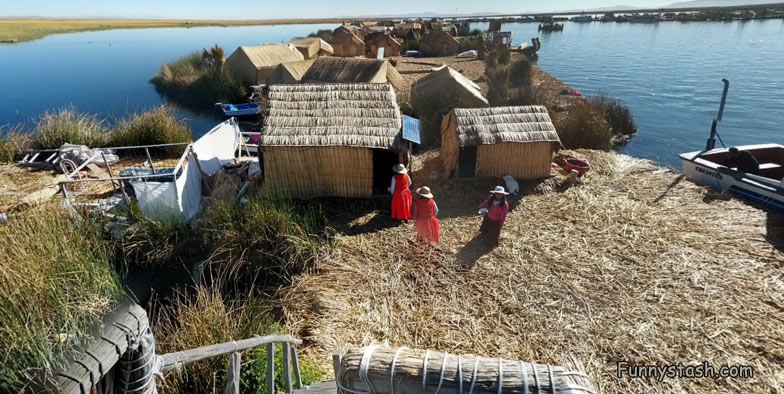
The Uros use bundles of dried totora reeds to make reed boats (balsas mats), and to make the islands themselves. The larger islands house about ten families, while smaller ones, only about thirty meters wide, house only two or three.
GPS Coordinates / -15.8183964,-69.9691149
The islets are made of totora reeds, which grow in the lake. The dense roots that the plants develop and interweave form a natural layer called Khili (about one to two meters thick) that support the islands. They are anchored with ropes attached to sticks driven into the bottom of the lake. The reeds at the bottoms of the islands rot away fairly quickly, so new reeds are added to the top constantly, about every three months; this is what makes it exciting for tourists when walking on the island. This is especially important in the rainy season when the reeds rot much faster. The islands last about thirty years.
GPS Coordinates / -15.8164057,-69.9721704
Each step on an island sinks about 2-4" depending on the density of the ground underfoot. As the reeds dry, they break up more and more as they are walked upon. As the reed breaks up and moisture gets to it, it rots, and a new layer has to be added to it. It is a lot of work to maintain the islands. Because the people living there receive so many tourists now, they have less time to maintain everything, so they have to work even harder in order to keep up with the tourists and with the maintenance of their island. Tourism provides financial opportunities for the natives, while simultaneously challenging their traditional lifestyle.
Aerial View of The Floating Village from above of Lake Titicaca in these VR Map Locations
Aerial View Of Uros Floating Village Lake Titicaca

